In the distance is Garibaldi Peak . If you look close you can see people on the top of the second peak . This picture was taken from the first peak , looking east .
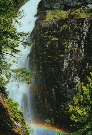
High Falls Creek High Falls Creek : Distance 6 km. One way Elevation: 725 m. Elevation gain : 640 m . Time : 4 hours. To get to this scenic hike , drive passed Squamish toward Alice Lake . Turn left at Alice Lake on the Squamish Valley Road . The road veers left after you cross a cement bridge . The trail head is 27 km. from highway 99 , the last 3 is on a good gravel road . You will pass a Power House on your right side and the parking is 1 km. Passed here . Go across the creek and the trail is marked by a small wooden sign . The trail starts out fairly easy but not for long . This is not a hike for the kids or if you bring a dog . The climbing is steady and steep , there is also an extremely deep canyon that ,at times , you are very close to . There are 5 braided ropes on the trail to help you up the steep parts .On your way up you will be scrambling over moss covered bluffs . The views of the Tantalus range and the Squamish River below will take your breath away . The
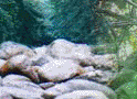
first view point is 15 minutes from the start of the trail . At the 1 km. Point you get your first view of the falls , this is a good spot to stop for a quick water break . Ascend the next bluff using the handholds and at the 2 km. point there is a sign " View Point . No exit " . This side trail only takes 5 minutes and will give you a close up view of the falls . It is also the coolest spot on the trail if it is a hot day . Once back on the main trail there is another rocky bluff and a braided rope to help you up . Climbing up another gully for
about 10 more minutes will bring you to a huge bluff top and an even better view of the valley below . This is a great place for lunch and a well deserved rest . The hardest part of the trail is now behind you . Back on the main trail you head northwest and enter into mature forest of Douglas fir .The change from rocky bluffs to cool forest is a welcome one .Continue up a small slope and you emerge on High Falls Forest Service Road . If you do not want to climb back down , turn left on the road for more views of the valley and a walk of 1.5 km back to your car . Rating: 3 View: 3
|